Keresés
Serbia castles
- Bács-castle
- Belgrade-fortress, Nándorfehérvár
- Bezerédy-castle (mansion)
- Botka-castle
- Dániel-castle (mansion)
- Dunderszky-castle I.
- Dunderszky-castle II. (mansion)
- Dunderszky-castle III. (mansion)
- Ecska-Lázár-castle (mansion)
- Engelmann-castle (mansion)
- Fernbach-castle I.
- Fernbach-castle II. (mansion)
- Galambóc, Golubac fortress
- Foeni-Mocsonyi-castle (mansion)
- Pannónia-castle (mansion)
- Pétervárad-Petrovaradin-fortress
- Karátsonyi-castle (mansion)
- Kárász-castle (mansion)
- Léderer-castle (mansion)
- Maldegheim-castle (mansion)
- Schulpe-castle (mansion)
- Spitzer-castle (mansion)
- Tallián-castle (mansion)
- Törley-castle (mansion)
|
|
||
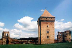 Photo: Nenad Seguljev Photo: Nenad Seguljev |
||
| A Szent István király alapította Bács vármegye székhelyén először valószínűleg földvár épült, ami az országosan feltárt és megismert ispánsági központokhoz hasonlóan gerendákból rekeszes szerkezetűre megépített és földdel töltött erődítmény lehetett. Miután 1072-ben a magyar királyi sereg elfoglalta a bizánciaktól Szerém várát, ide telepítették át a görög keleti ortodox püspökséget. A feljegyzések szerint eleinte még görög papok végezték az istentiszteleteket is a bácsi egyházban. A magyar-bizánci háborúk során többször is elfoglalták a görög seregek, így például 1164-ben maga Mánuel bizánci császár vonult be csapataival. A bácsi vár a középkorban A várat az 1241–1242-es tatárjárás idején felégették. A következő évtizedekből nem maradtak fenn adatok, hogy a lerombolt földvár helyett valamilyen erősség működött volna. A történészek álláspontja szerint csak Károly Róbert parancsára emeltek 1338–1342 között újabb erősséget a mocsarak közül kiemelkedő földháton. Az erődítmény a francia várak mintájára készült. A vár központi épülete egy többemeletes lakótorony volt, ahol a mindenkori várparancsnok lakott. A tornyot és a többi épületet vörösre égetett téglából készült várfal övezte, melyhez eredetileg nyolc bástya kapcsolódott. A várfalat háromszoros sáncrendszer vette körül, amelyeket őrtornyokkal és ágyúállásokkal erősítettek meg. A korabeli források szerint a külső védműrendszer területén csaknem ötezer főből álló hadsereg állomásozott, míg a belső vár védelmét több mint ötszáz katona látta el. A vár területén két templomot is építettek; a kisebbik a főpap magánszállásaként szolgált. A XV. század végén, Váradi Péter püspök idején vált Bács délvidéki reneszánsz központtá. Az első, napjainkig fennmaradt írásos említése is ekkor datálódik, amikor is 1435-ben a kalocsai érsekség mondhatta a magáénak a püspök irányítása alatt. A környező jobbágyfalvak alávetett népessége ide hordta be a földesúrnak járó szolgáltatásokat és adókat. Váradi egy ideig Mátyás király titkos kancellárja volt, de miután kegyvesztett lett, a visegrádi várban börtönözték be, s kiszabadulása után (Corvin János közbenjárására) költözött Bácsba. A török veszélyt világosan látván azonnal hozzálátott a lovagvár védőrendszerének felújításához, többek között úgy, hogy a sáncrendszerbe vezettette a Duna vizét. Az ő püspöksége idején, 1494-ben három hónapig vendégeskedett Bácsban II. Ulászló király. Az 1514-es Dózsa György vezette parasztháború idején a környéken jelentős számú keresztes hadak gyülekeztek, előlük a rettegő Frangepán Gergely kalocsai érsek bemenekült a bácsi erődítménybe. Rövidesen azonban a harcedzett nándorfehérvári helyőrség katonái szétverték a blokádot fenntartó fegyveres parasztokat. A törökkel vívott 1526-os sorsdöntő mohácsi csatában a magyar sereg fővezéri tisztét Tomori Pál kalocsai érsek látta el, aki odaveszett a küzdelemben. A győztes szultáni sereg rövid időre megszállta szeptemberben, majd kivonultak falai közül. Az állandó oszmán jelenlétre majd 1529-ben került sor, de a hódoltság északabbra terjedésével egyre kevesebb létszámú fegyveres állomásozott falai között. Így egy 1543-ból származó lajstrom szerint mindössze 106 főnyi zsoldos vigyázta falait, akik közül sokan a törökkel szövetséges rácok közül kerültek ki. Nincs pontosabban részletezve, de 1604-ben rövid időszakra elfoglalták a keresztény csapatok, aminek visszafoglalására csak két esztendő múltán indultak el a muzulmánok. Beérkezésüket azonban nem várták meg a várbeliek, hanem a védőműveket több helyen is puskaporral felrobbantva, elmenekültek a várból. A megszálló oszmán sereg rövidesen helyreállíttatta a romos részeit. 1628-ben már mindösszesen 6 topcsi (tüzér) és 10 főnyi gyalogos strázsálta falait, amit ismeretlen létszámú délszláv martalóc egészített ki. Buda várának véres ostrommal való visszafoglalása után déli irányban előretörő Habsburg sereg 1686. második felében kardcsapás nélkül vonult be a török által kiürített téglavárba. A következő időszakban a császári szolgálatba szegődött rácok fegyveresei állomásoztak falai között. Utolsó katonai szerepét a II. Rákóczi Ferenc vezette szabadságharc kezdeti szakaszában játszotta, amikor 1704. júliusában az ostromló kurucok felgyújtották az épületeinek tetőzetét, de elfoglalni nem tudták a hevesen védekező osztrák és rác helyőrségtől. A következő esztendőben azonban a hadi helyzet romlása miatt a német várkapitány felrobbantotta a védőműveit, majd elvonult. A továbbiakban már az időjárás szeszélye, társulva a környékbeli lakosság bontásaival fogyasztotta a téglavár falait és épületeit. Egyedül a magas lakótorony maradt meg teljes épségben, mivel azt termények tárolására használták. Korabeli adatok szerint csak 1842-ben a bácsi főispán szigorú tiltására hagytak fel a várrom tégláinak elhordásával, de azóta is gazdátlanul pusztulnak a történelmi viharokat látott épületrészek. Két ízben végeztek területén régészeti ásatásokat, de megóvása még a jövő feladatai közé tartozik. A 2000-es éves elején a Tartományi Műemlékvédelmi Intézet restaurálta a vár lakótornyát, de más feltárómunkára és felújításra nem került sor. (vajdasag.rs) |
||
| Bač Fortress (Serbian: Бачка тврђава / Bačka tvrđava) is a medieval fortress in Serbia, Vojvodina. It is located in the town of Bač. The medieval fortress in Bač is known as one of the great fortresses of its time in the Pannonian plain.[1] It was built by the town of the same name to the west, on a small island on the river Mostonga. The Fortress in Bač is known as one of the so-called "Water Towns", because it used to be surrounded by the Mostonga river on all sides, approachable only by the drawbridges. The fortress has a pentagonal basis on which corners are projecting towers. Inside the fort there is another, superior, central (or dungeon defender) tower. The tower has served as an important part of the defense system of the fortress, but also as an observation post.
Earliest Times At the head of Bačka county there were governors appointed by the king. Until the Mongol invasion in 1241, the governors were the managers of the area. They collected donations, set up military and civilian commanders. In addition to the governors of the fort there were also lower prefects, judges, and military personnel. Since the twelfth century, the custom of annual royal visits to the fort was established. Remodeled Ottomans Last Years |
||
|
|
||
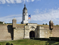 Photo:Островский Александр, Киев |
||
| Alapjait a 11. században rakták le, 1829-ig volt jelentős erődítmény. A vár fontos emlékei: Damad Ali pasa, Szelim pasa és Hasszán pasa síremléke, török csörgőkút, VI. Károly diadalkapuja, török fürdő, Nebojsa torony, vártorony, római castrum maradványai, Szent Petka templom, Sztambul-kapu A déli végvárrendszer tervszerű kiépítése az 1410-es években, Luxemburgi Zsigmond hadszervezeti reformjainak keretében kezdődött. A rendszer kiépítésében jelentős szerepe volt Zsigmond hadvezérének, Ozorai Pipónak, de a szervezés az ő 1426-ban bekövetkező halálával sem szakadt meg. Az 1426 májusában Lazarevics István szerb fejedelemmel kötött tatai szerződés közel húsz déli várat juttatott harc nélkül magyar kézre. Ekkor került magyar fennhatóság alá a nándorfehérvári vár is. Az erősség ettől kezdve – 1521-ben bekövetkezett elestéig – földrajzi helyzeténél és méreténél fogva is kulcsszerepet töltött be a magyar határvédelemben. Nándorfehérvár 16. századi ábrázoláson. Nándorfehérvár földrajzi helyzetéből adódó kulcsszerepe abból következett, hogy ha a török szultán Magyarország ellen nagyobb szabású hadműveletet akart indítani, mindenképpen el kellett vonulnia Nándorfehérvár közelében. |
||
| Belgrade Fortress (Serbian: Београдска тврђава, Beogradska tvrđava), consists of the old citadel (Upper and Lower Town) and Kalemegdan Park (Large and Little Kalemegdan) on the confluence of the River Sava and Danube, in an urban area of modern Belgrade, the capital of Serbia. It is located in Belgrade's municipality of Stari Grad. Belgrade Fortress was declared a Monument of Culture of Exceptional Importance in 1979, and is protected by the Republic of Serbia. The fortress remained a Byzantine stronghold until the 12th century when it fell in the hands of the newly emerging Serbian state. It became a border city of the Serbian Kingdom, later Empire with Hungary. The Hungarian king Béla I gave the fortress to Serbia in the 11th century as a wedding gift (his son married the Serbian princess Jelena), but it remained effectively part of Hungary, except for the period 1282–1319. After the Serbian state collapsed after the Battle of Kosovo in 1404, Belgrade was chosen as the capital of the principality of Despot Stefan Lazarević. Major work was done to the ramparts which were encircling a big thriving town. The lower town at the banks of the Danube was the main urban center with a new build Orthodox cathedral. The upper town with its castle was defending the city from inland. Belgrade remained in Serbian hands for almost a century. After the Despot's death in 1427 it had to be returned to Hungary. An attempt by Sultan Mehmed II to conquer the fortress was prevented by Janos Hunyadi in 1456 (Siege of Belgrade), saving Hungary from Ottoman dominion for 70 years. In 1521, 132 years after the Battle of Kosovo, the fortress, like most parts of the Serbian state, was conquered by the Turks and remained (with short periods of the Austrian and Serbian occupation), under the rule of the Ottoman Empire until the year 1867, when the Turks withdrew from Belgrade and Serbia. During the short period of Austrian rule (1718–1738), the fortress was largely rebuilt and modernized. It witnessed the Great Serbian Migration in the 17th century and two Serbian Uprisings in the 19th century, during the Turkish Period. The fortress suffered further damage during the First and the Second World Wars. After almost two millennia of continuous sieges, battles and conquests, the fortress is today known as the Belgrade Fortress. The present name of Kalemegdan Park derives from two Turkish words, kale (fortress) and meydan (battlefield) (literally, "battlefield fortress"). (Wiki) |
||
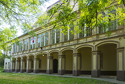
|
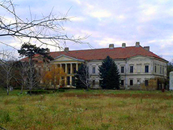
Bezerédj-kastély |
||
 |
|
|
| A klasszikus bejárattal rnedelkező kastélyt a sör és szeszgyáros Bezerédj Miklós tulajdonában épült fel. Később a kastélyt, a Dungyerszky család vette meg. A XX. században múzeumként rendezték be. Jelenleg zárva. (Wiki) | ||
|
Botka-kastély |
||
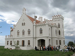 photo:sonjabgd - Panoramio Album |
|
|
|
A kastélyt Botka Béla országgyűlési képviselő, és főispán építtette 1904-ben Óléc közelében. Az épületet körbevevő pompás park mára teljesen megsemmisült, viszont a kastély szerencsére jó állapotban maradt fenn. A Botka birodalom fényes éveit az I világháború törte meg, és földosztás. A neogótikus épület téglalap alaprajzú, aszimmetrikus. Az épület egyszintes, egyik végén négyszögletes, csipkézett peremű bástyával. A központban lévő bejárati rizalit előtt a földszinten egyszerű portikusz áll, az emeletet csipkézett bástyákat utánzó pillérek vannak, ezek felett háromszögletes homlokzat kettős csúcsíves ablakokkal. A földszint kialakítása a középkori erődök kőépítését utánozza, boltíves bejárattal, ablakokkal rendelkezik, míg az emeleti rész csúcsíves ablakokat kapott. A legenda, és a helyi hagyomány szerint az egykori földbirtokos, Botka Béla az I. világháború után birtokának tőle el nem tulajdonított részét kártyán elveszítette, így ez a nagybecskereki bank kezelése alá került. Amikor felesége, Emma megtudta, hogy vagyonukat elveszítették, a kastély bástyájáról a mélybe vetette magát. Az épületet a banktól Franz Mein vette meg leánya számára, aki Milan Kapetanovhoz ment hozzá. Ettől kezdve Kapetanovónak nevezték a kastélyt. Jelenleg Sőtér Imre éjjeliőr bérli; használatlanul, üresen áll. A helyiek szerint egyedül Botka Emma tér vissza fehér galamb alakjában minden év augusztus 2-án éjjel. Forrás: Folberth P. – Gáspár K. (szerk.): Vajdaság száz csodája. Budapest 2006.
|
||
| Kapetanovo Castle (Serbian: Капетаново) is a neogothic castle located in the village of Stari Lec, in the Plandište municipality in northeastern Serbia. In 1991, it was included on the national list of monuments of culture of great importance, and since then it has been protected. The castle was built in 1904 by ispán of Torontál County (Kingdom of Hungary, Austria-Hungary) Béla Botka. He wanted to create a residence that would resemble a medieval castle, and that was one of the reasons for the construction of the neogothic palace. Kapetanovo is located near the road Vršac–Zrenjanin, about 2 km southwest from the small village of Stari Lec. After losing almost all of his wealth on gambling, owner Béla decided to sell the castle, as the last possible solution to solve his financial situation. After he told his wife Ema about this, she was so devastated that on the night of 2 August 1938, she climbed to the highest tower of Kapetanovo, poured gasoline on herself and burned to death. Nevertheless, in an auction in 1938, Kapetanovo was sold to a wealthy merchant Franc Maj. He purchased it as the main part of his daughter's dowry. After the wedding, she and her husband Milan Kapetanov moved in, and the castle took his name. During this time, Kapetanovo flourished. They created large fountains and gardens all around the castle compound, and the only part that was constantly locked was the tallest tower, where Emma Botka burned herself. Milan was Kapetanovo's owner up until the end of World War II; after the Law on Nationalization, the castle was seized by the communist Yugoslavia's government. Kapetanovo Castle is an example of neogothic architecture. It has two entrances, and around it there was a spacious park (now defunct) with a fountain. One of the most specific architectural specifications is a crow-stepped gable stretching along three sides of castle. With simple white façade and an elevated entrance, the building's harmonious proportions are pointed out with high square towers with crenellation. All the windows have sharp gothic arches, and with false arrow loops on top of the tower, the architect's idea of creating a pseudo-medieval castle is clearly visible. After the nationalization, the castle was mostly abandoned and empty for nearly 40 years. In 1987, reconstruction started, but it was soon abandoned after basic conservation work. Then, in August 2006, vast work on the restoration of the castle commenced, and it was renovated into a restaurant with a hotel As the castle is under protection of the Serbian Academy of Sciences and Arts as a monuments of culture of great importance, the reconstruction was a faithful restoration of the original design. (Wiki) |
||
|
Daniel-kastély |
||
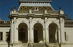 photo: |
||
| A kastélyt 1898-ban építették. Dániel László és családja nem sokáig évezhették a kastélyt, mert a trianoni döntés miatt Budapestre költöztek. A kastélyban 2000 kötetes könyvtár is volt. Kosta Ilic vette meg a kastélyt, majd leszármazottjátol Vlad iljic-től hazaárulásért elkobozták. Volt árvaház is jelenleg Vuk Karadzic általános iskola. A kastélyt szimmetria, és klasszikus vonalvezetés jellemzi. A tetőt színes kerámia lapok borítják. A kastély műemlék, és parkja védett terület. | ||
|
Dungyerszky-kastélyhotel I. |
||
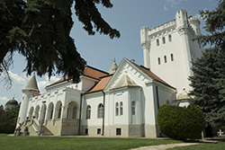 photo: Donatello |
||
| A Fantaszt szálló Óbecsén található, Bogdan Dunđerski nagybirtokos kastélyában. Az épületet 1919 és 1923 között építették, az 1980-as években szállóvá alakították át. Nevét a tulajdonos Fantaszt nevű telivér ménjéről kapta. Az épületegyüttes Bácska keleti részén, a Becse és Topolya (Bačka Topola) közötti úton Becsétől 14 km-re van. A 65 hektárnyi terület magában foglalja a kastélyt, a lovardát, a kápolnát, a kiskastélyt, a parkot, és a kiszolgáló épületeket. Bogdan Dunđerski nagybirtokos a 20. század elején azért építette, hogy gazdagsága és befolyása nagyságának jelképe legyen. A Bogdán kápolna A család Hercegovinából származik, Gacko környékéről. A 18. század elején kerültek Szenttamásra (Srbobran). A vagyon alapjait itt veti meg Gedeon Dunđerski. Ezt fia Sándor gyarapítja. Így három generáció alatt a nagybirtokosok sorába léptek. Bogdan Dunđerski 2600 hold (kb. 710 ha) földet örökölt. A földművelés mellett a lovakkal is foglalkozott. A ménese messze földön híres. Időnként 1400 darab telivér is a tulajdonában volt. A kastélyban több építési stílus keveredik. A torony és a négy szögletes kupola neogótikus. A bejáratok neoklasszicista stílusban lettek kivitelezve. A neobizánci stílusban épült kápolnát 1923-ban építették. Belsejét Uroš Predić festőművész ikonjai díszítik. A kastély közvetlen környezetében van egy nyitott medence, amit a volt gazda személyes vendégei vehettek igénybe. Magát a kastélyt tömör fal övezi, amelyet két kovácsoltvas kapu ékesít. Az egykor alapított lovarda ma is sikeresen szolgálja ki a lovaglás szerelmeseit. A kastélyt körülvevő, szépen ápolt park pedig teljessé teszi az idelátogatók időtöltését. (Wiki) |
||
| Fantast Castle (Serbian: Фантаст / Fantast) is a Serbian castle built by Bogdan Dunđerski from 1919 onwards. Dundjerski family originally came from Herzegovina to Vojvodina (Serbia) in the late nineteenth century and at one point he owned 1500 hectares of land.
The castle became one of the most famous castles in the Austro-Hungarian monarchy. After 1945, it was heavily bombed and seized by the Communists at that time, who proclaimed it as a state wealth. Most of the original furnishings have not been returned and today 65 hectares is what remains. It is said that Bogdan Dunđerski built the lavish castle and lands to prove to all that he was not bankrupt as had been rumored. He never married but it was known that he had a great fondness for fine women, horses and wine. The castle lies 12 km from the town of Becej and about 60 km from Novi Sad and today it is used as a tourist destination, where it serves as a hotel with restaurant. Tourists are free to enter and explore the castle's large park and the mausoleum where former owners are buried as well as play on the tennis courts and use the runway for small airplanes. A fully functioning horse stable and farm still exists, it was famed for producing some of the best thoroughbreds in the lands, once numbering 1400. There is also the Church of St George, inside of which is a painting of the Virgin Mary by the artist Uroš Predić, however it is said that the face was changed to that of Mara Dinjacki (the blacksmith's wife), whom Dunđerski was in love with. There is also a small ostrich farm to visit and guided tours around the castle and lands are 1 euro per person. (Wiki) |
||
|
Dungyerszky-kastély II. |
||
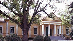 Photo: |
||
| If by chance you find yourself in the village of Hajducica, you will find there the castle “Damaskin” that holds the secret of the rise and fall of the famous family Dundjerski, their fates, intrigues, love, about Lenka, daughter of Lazar Dundjerski, whose beauty has been an inspiration for many an artist, and a small lake in the park which, the legend says, stole dreams from the painter Jatar. The castle was named after Istvan Damaskin who founded the village and in 1829 built the castle. In the early 20th century, Lazar Dundjerski bought the property with pre-built castle turning it into classical style. He also introduced bathrooms and steam heating. (banatheritage.com) |
||
| A földterület az 1848-ban vitézül harcoló Damaszkin (Damaszkin Arzén afrika utazó), családé volt, akik eladták a birtokot a Dungyerszky családnak. Az épületet Dungyerszky Lázár emeltette 1901-ben. A kastély klasszicista stílusú. A család virágzó gazdaságot tartott fenn, mely híres volt parkjáról, virágkertészetéről. A háború végett vetett a család tulajdonlásásnak, és az épületet a helyi mezőgazdasági kombinát kapta meg. | ||
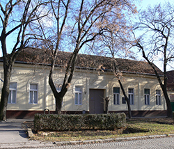
| Dunderszky kastély III. | ||
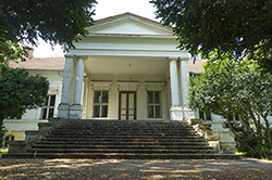 Photo: Donatello |
||
|
A XIX. századi klasszikus vonalvezetésű kastély főbejáratán dupla oszlopzattal Törökbecse külterületén. Utolsó magántulajdonosa Emília Dunderszky Lázár lánya volt. Egykoron kiránduló övezet is volt, ma elhagyatottan áll kis parkjában zárva. |
||
|
Harnoncurt-Lázár kastély |
||
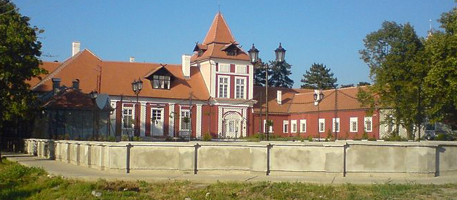 Photo: Vill6 |
||
|
A piros kastélynak emlegetett, angol stílusú, tornyos, manzárdtetős úrilakot az Écskát birtokló Lázár család egyik sarja, Lázár Ágoston építtette a XIX. század első felében. A kastély ünnepélyes megnyitójára 1820. augusztus 29-én került sor többnapos ünnepség keretében, mikor is annak harmadik napján Liszt Ferenc itt adta első nyilvános fellépését. |
||
| Almost two centuries ago, Armenian wealthy man Lazar Lukac opened the newly-built castle on the left bank of the Begej River, near the city of Zrenjanin, which he called Kastel. The ball gathered many guests from European courts, and they were thrilled by the virtuoso playing of Franz Liszt, back then still only a child prodigy, but later the famous composer. Today, the castle in Ecka is a hotel that offers royal enjoyment. There are more than 30 castles in the Serbian “grain basket” of Vojvodina, more or less preserved. Along with Carska Bara marsh, the Kastel Ecka is a tourist attraction in this part of the northern Serbian province. It’s story begins in 1783, when Lazar Lukac bought 30 thousand acres of land on an auction in Vienna. He came from Timisoara, where he had lived with his family, and started desiccating the heavy Banat soil, making canals and creating fertile land. The physical labor was first done by Germans, but they did not stay for long, so he brought Bulgarians. They also could not bear it for long, just like Hungarians or Serbs after them. Finally, Romanians were not only the hard working people, but they had also settled there, so to this day they are the majority among the 5,000 inhabitants of Ecka, says Vlada Dasic, the tourist worker from Zrenjanin. There are more than 30 castles in the Serbian “grain basket” of Vojvodina, more or less preserved. Along with Carska Bara marsh, the Kastel Ecka is a tourist attraction in this part of the northern Serbian province. It’s story begins in 1783, when Lazar Lukac bought 30 thousand acres of land on an auction in Vienna. He came from Timisoara, where he had lived with his family, and started desiccating the heavy Banat soil, making canals and creating fertile land. The physical labor was first done by Germans, but they did not stay for long, so he brought Bulgarians. They also could not bear it for long, just like Hungarians or Serbs after them. Finally, Romanians were not only the hard working people, but they had also settled there, so to this day they are the majority among the 5,000 inhabitants of Ecka, says Vlada Dasic, the tourist worker from Zrenjanin. The hotel part of the property is built in the English style, it has 38 rooms and 100 seats in the restaurant, while on the second floor are two smaller halls for promotions. In the park, in front of the hotel, is the replica of the original fountain, whose original parts are kept in the hotel interiors. Once, there were also horse stables and corrals, while also preserved are parts of a mill. Also standing in the park is the monument to hunters, erected after the killing of Lazar Lukac’ youngest son, said to be murdered by his middle brother, in a quarrel over cattle. That it is not just a legend, we see from the text etched in the monument, warning that brothers must live in harmony and brotherly love must be guarded with utmost care. The oldest son also died tragically, in a duel, while defending the honor of a lady. His name is related to the building of the catholic church of St John the Baptist from 1794, raised next to the castle. Four decades later it burnt, and the new one was built in 1864 by general and count Zsigmond Lazar, and painted by Flemish masters. Allegedly, this church was connected to the castle via underground passage. (voiceofserbia.org) | ||
|
Engelmann-kastély |
||
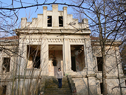 Photo: Photo: |
||
|
Az Engelmann kastély Ada határában található Pobeda és Kavilló falvak között. Adáról indulva Törökfalun keresztül vezet az út. Törökfalu központjában csak balra kell fordulni és máris a tanyavilágot átszelő, lepukkant betonúton zötykölődünk. Kavilló után Svetićevo következik, majd a faluból kiérve az első kibetonozott leágazásnál jobbra kanyarodunk és néhány perc múlva már ott is vagyunk a kastélynál, ahol a betonút is véget ér. (vajdasagiskaccok.blogspot.hu) Az Engelmann kastély parkja
|
||
|
(Wikipédia) |
||
|
Fernbach-kastély I. |
||
 Photo: Donatello |
||
|
A kastélyt Fernbach Károly Bács- Bordrog megye főispánjának megbízásából építették. A terveket 1906-07-ben Raichle József Ferenc tette papírra, bár sokak szerint a kastély tervezője Hikisch Rezső is lehetett. A Fernbach család gazdagsága az I. világháborúig tartott. A kastély építését a feleség ihlette, aki nagyon szerette a természetet. Madártani megfigyeléseket végzett, és publikált. A terület az ő nevét viseli: Babapuszta, mert a bozsoki karácson Dórát babának becézték. Slobodan Milosevic idejében moziterem, és étterem is volt a kastélyban, és szépsége miatt sok filmforgatás helyszíne is volt a toronnyal kápolnával pincével rendelkező kastély. |
||
|
Fernbach-kastély II. |
||
 |
||
| Eklektikus kastély a 19.század végéről. Klasszikus, és barokk elemek is keverednek az épületen. Téglalap alaprajzú, tágas, oszlopokkal díszített terasszal. Egykor Fernbach Bálint tulajdona volt, akit elsősorban az afrikai vadászat, és a gazdálkodás érdekelt. A Vajdaságban komoly gazdasággal rendelkezett egykor a Fernbach család. Később az épületetet a Dundgyerszky család vette meg. A kastélyhoz szép park is tartozik, sétánnyal három hektáron. A parkban több száz éves fák és fenyők találhatóak, és egy mesterséges tó is van a közelben. Jelenleg a Bácska Topolya kezelésében van. | ||
|
Galambóc, Golubac-fortress |
||
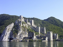 photo:Denis Barthel |
||
| Galambóc vára helyén egykor Columbaria római erőd állott. A várat a rácok (későbbi szerbek) építették, 1334-ben Károly Róbert hódította meg hadjárata során. 1387-ben Lázár szerb fejedelem ostromolta. A török először 1391-ben foglalta el, de ekkor még Perényi Péter visszafoglalta. A szerb várat 1427-ben szerződéssel szerezte meg Zsigmond király, de annak szerb kapitánya a töröknek adta át 12 000 aranyért. 1428-ban Zsigmond ostrom alá vette, de a szultán serege felszabadította, és a király is alig menekült meg. 1458-ban Mátyás serege ostromolta, de a belharcok miatt kénytelen volt az ostromot félbeszakítani. 1481-ben Kinizsi Pál foglalta el, de nemsokára megint török kézre került. 1688-ban Nándorfehérvár eleste után török őrsége feladta. Festői romjai a Duna partján állnak Galambóc mellett. (Wikipédia) | ||
| Golubac Fortress (Serbian: Голубачки град or Golubački grad, Hungarian: Galambóc vára, Bulgarian: Гълъбец, Romanian: Cetatea Golubăț, Turkish: Güvercinlik Kalesi) was a medieval fortified town on the south side of the Danube River, 4 km downstream from the modern-day town of Golubac, Serbia. The fortress, which was most likely built during the 14th century, is split into three compounds which were built in stages. It has ten towers, most of which started square, and several of which received many-sided reinforcements with the advent of firearms.
Golubac Fortress has had a tumultuous history. Prior to its construction it was the site of a Roman settlement. During the Middle Ages, it became the object of many battles, especially between the Ottoman Empire and the Kingdom of Hungary. It changed hands repeatedly, passing between Turks, Bulgarians, Hungarians, Serbs, and Austrians, until 1867, when it was turned over to the Serbian Knez, Mihailo Obrenović III. Now, it is a popular tourist attraction in the region and a sightseeing point on Danube boat tours. Golubac's early history is uncertain. Inscriptions and evidence of older defensive structures in the area show the presence of a Roman settlement, sometimes named "Columbaria, long before the creation of Golubac. From 803 to 1018, the area belonged to the First Bulgarian Empire, to Byzantium from then until 1193, and the Second Bulgarian Empire until 1257. The area remained in Bulgarian hands from then until the Ottoman conquest in the 15th century, with control of the region changing many times between Hungarians, Bulgarians and Serbs before then. It is also unclear whether the medieval fortress was built by Bulgarians, Serbs or Hungarians, or how many towers it had originally. However, an Orthodox chapel built as part of one tower shows that it, at least, was built by a local noble. There is also uncertainty about when construction started, although it is generally agreed that the majority of the fortress was built early in the 14th century. The first known record of Golubac is in Hungarian sources from 1335, when it was occupied by Hungarian military. Sometime between 1345 and 1355, Serbian Tsar Stefan Dušan toured the Braničevo region, which was part of Serbia. He also visited Golubac, which was under the command of Castellan Toma, Voivode of Transylvania. After Dušan's death, the House of Rastislalić gained influence in Braničevo, later winning independence. According to Serbian chroniclers, Knez Lazar evicted the last Rastislalić feudal lord, Radič Branković, in 1379, then presented outlying villages to monasteries in Wallachia. By the time of the Battle of Kosovo in 1389, Golubac was held by Serbia. It is unclear when or how it changed hands, though one source puts it later than 1382 After the battle, the fortress was lost to Sultan Bayezid I, marking the first possession by the Ottoman Empire. In 1391, Golubac switched hands twice. Hungarian Timişoaran Comes Péter Perényi won it, but shortly afterwards lost it again to the Turks. Later, it returned once again to the Kingdom of Hungary. The first extended Serbian possession of Golubac began in 1403 when Sigismund, King of Hungary, ceded it as a personal fiefdom to Despot Stefan Lazarević after he became a Hungarian vassal. When the issue of Stefan's successor came up in 1426, he and Sigismund met in May in Tata to discuss it. A contract was written stating that Sigismund would accept Đurađ Branković as successor on the condition that Golubac, Belgrade, and Mačva were returned to Hungary when Stefan died. After Stefan's death in 1427, Sigismund hurried to have the clauses of the Tata contract fulfilled, and Belgrade and Mačva were handed over without a problem. However, Golubac's commander, Voivode Jeremija, demanded a compensation of 12,000 ducats. When Sigismund refused to pay, Jeremija handed Golubac to the Turks, who turned it into the pasha's residence. Despite gaining Golubac, Sultan Murad II was not pleased with the increased Hungarian influence elsewhere in Serbia, so he sent his army to attack. One squad came from Golubac and targeted nearby Serbian and Hungarian settlements in the Braničevo region. In response, Đurađ personally travelled to Golubac, promising forgiveness to Jeremija and urging him to return the fortress by any means possible. The Voivode refused, and attacked the Despot when he and his escort attempted to enter the walls.These betrayals were followed in 1428 by the Battle of Golubac. Around April 1428, Sigismund amassed an army of 25,000 infantry, 6,000 Wallachian archers led by Prince Dan II, 200 Italian artillery, and a number of Polish cavalry on the far side of the Danube, then attacked Golubac and the Turks. He also had ships attacking from the river, one of which was commanded by Cecília Rozgonyi wife of Timișoaran Comes István Rozgonyi. Murad rushed to help the besieged Turks, arriving in late May. Sigismund, who did not wish to fight the bigger army, finalised a treaty by early June. Once part of the Hungarian army had withdrawn to the far side of the river, however, the Turkish commander Sinan Bey attacked their rear, capturing and killing those who remained among them the Polish knight Zawisza Czarny. Sigismund was nearly caught with the rest of his army; the intervention of Cecília Rozgonyi is solely responsible for his rescue. During this and other fights resulting from Stefan's death, southern and eastern Serbia, including the Monastery of Daljša near Golubac, suffered heavily. It was after this fighting, however, that Sigismund was first referred to as "our Emperor", in the memoir of a Daljšan monk, in contrast to the Turkish "pagan emperor". The Ottoman Empire retained control of Golubac throughout its occupation of the Serbian Despotate. After years of fighting, which resulted in the Hungarian army expelling the Ottomans from Serbia, the Peace of Szeged restored the Despotate late in the summer of 1444. Included in the redefined territory, after much discussion, was Golubac Fortress.[13] However, the Turks once again conquered it after the death of Đurađ Branković in 1456. In 1458, Matthias Corvinus of Hungary regained the fortress,[14] but lost it to Mehmed II that same year. The years 1481–82 led to more fighting between the Hungarians and Turks. During the fall of 1481, while Golubac was held by the Ottoman Empire, Timișoaran Comes Pál Kinizsi undertook an expedition against the Turks in the Temes area. On November 2, 1481,he turned his army of 32,000 men south towards the Danube, pushing to Kruševac. At Golubac, a thousand Turkish cavalry were killed or taken prisoner, 24 ships were sunk, and Mihaloğlu İskender Bey, pasha of Ottoman-held Smederevo and leader of the Turkish army, was beheaded at the gate by Jakšić, one of Kinizsi's men. The Turks were forced to retreat and leave the fortress behind. Kinizsi's foray was only a raid, however, and shortly after he returned to Temes. The Turks, who had suffered heavily but did not lose any land, retook Golubac and quickly improved its fortifications. Golubac was held by the Habsburg Monarchy between 1688 and 1690 and 1718 and 1739. Serb rebels controlled it during Kočina Krajina in 1788–91, and again from 1804–13, during the First Serbian Uprising. Afterwards, it fell back under Ottoman control until 1867 when it, along with Kalemegdan and other towns in Serbia, was given to Knez Mihailo of Serbia. From the late 19th century into the early mid-20th century, bloodsucking flies sometimes referred to as "Golubac mosquitoes" thrived in the area. They were particularly dangerous to livestock, some years killing off entire herds of cattle. After World War I, a road was constructed that went through both of the fort's portcullises. This road is the shortest link between Serbia and eastern parts of the Balkan peninsula. Between 1964–72, a hydroelectric dam was built in the Iron Gate gorge, significantly elevating the river's water level. As a result, the lower edge of the slope and corresponding parts of the fortress are now flooded. From the beginning of the 21st century, much of the fort has been overgrown, making most of the sections higher on the hill inaccessible. During the spring of 2005, a public project to restore the fort was started. Most of the plants were removed and certain parts, like the fountain in the moat raised in honour of knight Zawisza Czarny, were repaired. The walls, towers and stone stairs are in good condition, but the wooden floors and steps have rotted out, making most of the upper floors impassable. Golubac has also gained popularity as a tourist attraction. Two key reasons are the major road that passes through it, and its proximity to Lepenski Vir, making the two locales a touristic whole. (Wiki) |
||
|
Foeni-Mocsonyi-kastély |
||
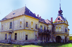 Photo: |
||
| Since the second half of the 19th century until the Second World War the building was radiating beauty, exactly from 1859 when it was built as a private estate owned by the family Mocioni, and after the marriage of Georgina Mocioni with the Earl Bisingen, it became the property of the count’s family, hence the name “Bisingen”. The castle was built in classical style with an unusual and lavish decoration of wrought iron. It belongs to the type of a field mansion, i.e. it is built as a free object surrounded by park. (banatheritage.com) | ||
|
Az 1717. évi kamarai jegyzékben Vlaikovazként említették, ekkor már 22 ház állt itt, és az 1761. évi térképen pedig Weikovez néven szerepel. 1829-ben gróf Bethleni Bethlen Imre, János, Ferencz, Elek, Gergely, György és Pál kárpótlásul kapták a borgiai birtokokért. 1845-ben a birtok kétharmadrésze a gróf Bethlen, egyharmada pedig a Foeni Mocsonyi-családé volt. |
||
| Pannónia-kastély | ||
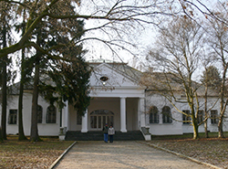 Photo: |
||
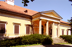
| Pannónia 1846-ban épült kastélya is a Ferncbach család tulajdonában volt, majd Falcione Ádám vette meg, a klasszicista bejárattal rendelkező kúriát. Az épületben látható néhány eredeti tárgy: tükrök, cserépkályha, padlóburkolatok, diófa íróasztal, stukkódíszek, és még egy kis könyvtár is. Napjainkban a Bacska Topolyaiak egyik kedvenc kiránduló helye. Mellette áll a Biser szálloda, amely gondozza a kastélyt is. | ||
|
Pétervárad-erőd |
||
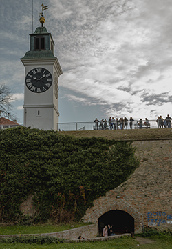 Photo:Donatello |
|
|
| Petrovaradin Fortress (Serbian: Петроварадинска тврђава or Petrovaradinska tvrđava, pronounced [pɛtrɔv̞arǎdiːnskaː tv̞ř̩dʑav̞a], Hungarian: Péterváradi vár, German: Peterwardein) is a fortress in Novi Sad, Serbia. It is located in the province of Vojvodina, on the right bank of the Danube river. The cornerstone of the present-day southern part of the fortress was laid on October 18, 1692, by Charles Eugène de Croÿ. Petrovaradin Fortress has many underground tunnels as well (16 km of underground countermine system). In 1991 Petrovaradin Fortress was added to Spatial Cultural-Historical Units of Great Importance list, and it is protected by the Republic of Serbia. A gravure from 1821Recent archeological discoveries have offered a new perspective not only on the history of Petrovaradin, but on the entire region. At the Upper Fortress, the remains of an earlier Paleolithic settlement dating from 19,000 to 15,000 BC has been discovered. With this new development it has been established that there has been a continuous settlement at this site from the Paleolithic age to the present. During the excavations carried out in 2005, archeologists also discovered another significant find. Examining remains from the early Bronze age (c. 3000 BC), ramparts were discovered which testify that already at that time a fortified settlement existed at the Petrovaradin site. The first larger fortifications were created with the arrival of the Romans who built the fortress (Cusum) which was a part of the fortified borders (Limes) along the Danube. The turning point in the history of the area came in 1235 AD when King Bela IV of Hungary brought a group of the Order of Cistercians from France. This order of monks built the monastery Belakut upon the remains of the Roman fortress of Cusum. The walls of this monastery were built between 1247 and 1252 and represent the fortifications at this site during the Middle Ages. The fortress was strengthened due to the threat of Turkish invasion. However the fortress fell after a two-week siege in 1526. In 1692, the Hofkriegsrath ordered engineers to Petrovaradin to investigate the area in order to build a new fortress. Count Keysersfeld received both financial and personnel support. The first plans for the fortress were designed by the engineer Colonel Count Mathias Keyserfeld, and afterwards by Count Luigi Ferdinando Marsigli (1659–1730). The works in the field were led by the engineer Colonel Michael Wamberg who died in 1703 and was buried in the church of the Franciscan monastery which today serves as part of the present day military hospital. On September 9, 1694, the Grand Vizier Sürmeli Ali Paşa arrived at Petrovaradin Fortress from Belgrade. A siege of 23 days was laid on, however poor weather conditions in October forced the Turkish forces to retreat towards Belgrade with their task left unfinished. The victory of the Austrians under the command of Prince Eugene of Savoy at Senta on September 11, 1697 resulted in creating the conditions for the conclusion of the peace at Karlowitz in 1699. A new war with the Turks was imminent. The Austrian lack of interest in war, plus the war reparations suggested by the Austrians to the Turks in the interest of the Venetian Republic all served as reasons for the renewal of Turkish aggression towards Austria. In order to prepare for the upcoming battle, Prince Savoy ordered the concentration of Austrian troops around Futog under the temporary command of Count Johann Pálffy. Prince Savoy arrived personally on July 9. The entire Austrian army numbered 76,000 troops. In the meantime, the Turkish army concentrated 150,000 troops at Belgrade. The decisive battle between the Austrian and Turkish armies took place on August 5, 1716 at Petrovaradin. The Austrians were led by Prince Savoy and the Turks were under the command of Grand Vizier Silahdar Damat Ali Pasha. The victory of the Austrian army signaled the end of the Turkish threat to central Europe. After the completion of the Petrovaradin Fortress, there was never any further threat from Turkish forces. The last offensive military role the fortress was to play was during the Hungarian Revolution in 1849, when Austrian troops tried to force the Fortress to surrender after a blockade. The answer came in the form of the shelling of Novi Sad on June 12, when two-thirds of the city was destroyed. During the following period, the fortress served as a military barracks and storage facility. Following World War I, Petrovaradin became a part of the Kingdom of Serbs, Croats and Slovenes (Later known as Yugoslavia). During these years, the old fortresses at Belgrade, Osijek, Karlovac and Slavonski Brod which were built in the 17th century were razed because they had lost their military significance. The engineer Colonel Dragoš Đelošević, who was responsible for the destruction of the fortresses decided to save Petrovaradin because it was, to him, far too beautiful to suffer the fate of the other fortresses. The minute and hour hand on the clock tower are reversed, with the small hand showing minutes, and the big hand showing hours. It was created as such so that fishermen on the Danube river can see the time from a long distance. The "Reversed clock" as it is known, is one of the landmarks of Petrovaradin fortress. (Wiki)
|
||
| A vár története Ókor A történelmi leletek arról tanúskodnak, hogy a vár már az őskorban is létezett. A Tarcal (Fruška Gora) lankáin volt a Cusum, később Acumincum nevű római erődítmény. A korai középkorban Pétervárad Bizánchoz tartozott. A XII. században jelentős szerepe volt Bizánc és Magyarország ellen folytatott háborúkban. IV. Béla magyar király 1237-ben Péterváradot a cisztercita Ukurd kolostornak adományozta, ekkor a Belafons nevet kapta. Itt említik meg először Peturwarod néven írásos dokumentumban. 1439-ben Albert király Garai Jánosnak adta. Az 1440–1441-es harcokban Újlaki Miklós foglalta el, majd újra a Garaiaké. 1463-ban Péterváradon szábort tartottak, amelyen szerződést kötött Mátyás király és Velence, amely értelmében szövetségesek lettek a török birodalom ellen. Ennek ellenére 1526. július 15.-én a várost elfoglalta a török, míg a várat 12 napi kemény ostrommal csak július 27.-én tudta bevenni. Pétervárad török hatalom alatt volt több mint 160 évig, egészen 1688-ig, amikor is Miksa Emmánuel bajor választófejedelem felszabadította. A régi vár helyén 40 méteres magaslaton 1692-ben kezdődik a Habsburg birodalom legnagyobb erődítményének építése Vauban várépítési módszere alapján. Az építés első szakasza 1726-ig tart, míg a második 1753–1780-ig. Ez korának egyik legpompásabb katonai építménye volt Európában. „Gibraltár a Dunán” ahogyan nevezték egyesek, leginkább Mária Terézia uralkodása idején épült, ekkor nyerte el mai formáját. A vár 112 hektáron terül el, egy egyedülálló alagút folyosórendszerrel melynek hossza 16 km. 1848. október 15.-én a város feltűzte a magyar háromszínű zászlót. December 12.-én az osztrák érzelmű tisztek zavargást idéztek elő a várban, de a Don-Miguel ezred magyar érzelmű legénysége azonban az ágyukat és több pontot elfoglalván, tisztjeinek ellenszegült. 1849. június 5.-én Kiss Pál honvédtábornok kapta meg az erőd parancsnokságát Vukovics Sebő miniszter javaslatára. Az esemény hatására kisebb összetűzésbe került a várat felszabadító Perczel Mórral, hisz ő magának akarta e tisztséget. Kiss Pál parancsnokságával a vár 1849. szeptember 7.-én, egy meg nem érkezett levél miatt feltétel nélkül kapitulált. A honvédség IX. hadteste azaz 5800 főnyi katonaság tette le a fegyvert, 200 tábori és várágyú került a császáriak kezébe. A legénység még aznap, vagy az elkövetkezendő napokban elvonulhatott. Kiss Pált és a tisztek egy részét (180 fő) november 7.-éig fogva tartották. Pétervárad tehát a szabadságharc utolsó előtti védőbástyája volt Komárom előtt. Az első szerb felkelés idején a péterváradi vár fegyvertárában rakták össze a felkelők első ágyúit, melyeket Szerémségen keresztül Macsóba csempésztek át.A felkelés megbukása után a várba internálták Karađorđet és vajdáit. A felkelés ideje alatt 1849. június 12.-én a magyar hadsereg a várból bombázta Újvidéket. Manapság Az óra és a perc mutatói a toronyórán fel vannak cserélve, a kis mutató a percet, a nagy mutató az órát mutatja. Így a halászok a Dunán láthatják az időt messziről. A "fordított óra", a péterváradi erőd jellegzetessége. (Vajdaság enciklopédiája) |
||
| Karátsonyi-kastély | ||
 |
||
| When you enter Novo Miloševo just pay attention on the left side of the road and you will see the castle, you can miss it because of it’s large. The castle was built by Lajoš Karačonji between 1842. and 1846. on his property in Beodra (today joined with Novo Miloševo). There are also some economic objects: horse stable, stables, warehouses and servant sections, which together with the main building of the castle represent perfect done complex, by style and architecture. Today in the castle is the chemical industry Hinom. Inside the castle is made for the needs of the factory, but it is not restored. On the back side the façade of the castle is in very bad condition. The castle is the monument of culture of the great importance.
The castle is not open for the visitors! (vojvodinaonline.com) |
||
| 1781-ben Karátsonyi Bogdán vásárolta meg a kincstártól a beodrai uradalmat, 1794-ben. A család a XVIII. – XIX. században a Magyarország iránt tanúsított hazafiságának köszönhetően köztiszteletnek örvendett. Beodrát első ízben 18 ezer holddal együtt Karátsonyi Kristóf fia kapta donációba a törökök ellen küldött harcosaiért a XVIII. század elején – ekkor vette fel a család a „Karátsonyfalvi és Beodrai gróf” nevet. A család egy másik ősének, Karátsonyi Lázárnak (Torontál vármegye alispánja, majd országgyűlési követ) pedig közjóérti áldozatkészségéért, valamint a franciák ellen vívott háborúba küldött száz fős saját csapatáért Ferenc császár a Temes vármegyében fekvő nagy-zsámi uradalmat adományozta. A magyar grófi címet 1874-ben Karátsonyi Guidó (császári és királyi kamarás, belső titkos tanácsos, országgyűlési követ, osztrák gróf) szerezte meg, aki jelentős adományokkal támogatott különböző alapítványokat és a Magyar Tudományos Akadémiát. A gróf országos ismertségre az erénydíj alapításával tett szert 1881-ben, amelyet a vagyontalan, de jó erkölcsű leányok kiházasítására hozott létre. Fia, Aladár és unokája, Jenő is császári és királyi kamarás, utóbbi főrendházi tag volt. A család tárgyi emlékeinek szomorú sors jutott, mint annyi más magyar történelmi családénak – 1842-1846-ban épített egyemeletes, klasszicista stílusú urasági kastélyuk, amely az egyik legszebb bánáti kastély, kísérő építményével együtt egyelőre pusztulásra van ítélve. Az építtettő Karátsonyi László volt. A kastélynak 2500 kötetes könyvtára is volt. Utóbbi utolsó tulajdonosát, Mohot Ádámot 1944. őszén azok a partizánok verték agyon, akiknek ő korábban kenyeret adott. (vajdasag.rs) Karátsonyi Guidó vezette be hazánkban a rózsaesküvők hagyományát. A kastélyban a közelmúltban vegyi üzem működött, ma elhagyatott. |
||
|
Kárász-kastély |
||
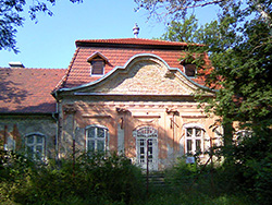 Photo: Donatello |
||
| Kárász Miklós a Csongrád vármegye főjegyzője, királyi tanácsos volt. 1797-ben hunyt el, a horgosi templomban van eltemetve. A kastélyt Grassalkovich stílusúnak is mondható, a 18. század végén épült barokk stílusban, egykor szép barokk kapuzattal, amelyen át a kastélyudvarra lehetett bejutni. Felújítása lassan halad. Megsemmisülése már az államosításkor elkezdődött. Nyűtte a katonaság, az iskola, gondját azonban senki sem viselte. Az 1956-os magyar forradalom és szabadságharc leverése után a menekültek átmeneti befogadó-központja volt. A kifosztott, a megbontott tetőszerkezetű, omladozófélben levő műemléket a község és a műemlékvédelmi intézet gondoskodó vezetősége igyekszik megmenteni. Forrás: Tört.délvidék |
||
|
Léderer-kastély |
||
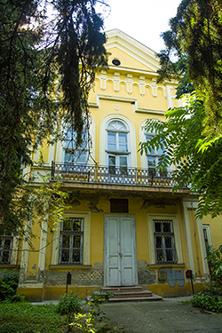 Photo:Donatello |
|
|
| A kastélyt marczibányi Lőrincz kezdte el építtetni a XIX. század elején, majd sefőző dinasztia vette meg, de ők sem fejezték be az épületet. A kastélyt Sváb Károly fejeztette be, majd eladta Léderer Artúrnak, és Léderer Károlynak. Az épület kétszintes szimmetrikus vonalvezetéssel. Stílusa az eklektika jegyeit viseli. A Léderer család irányítása alatt szép mintagazdaság működött , és a kastély parkja is ekkor lett igazán jól kialakítva. A kastély utolós Léderer ura György volt, aki zsidó származása maitt elmenekült a német megszállás miatt. A kastélyt hermann Göring kapta meg. A felszabdulás után államosították, és a csókai mezőgazdasági szövetkezet kapta meg. Jelenleg bezárva, pusztuló állapotban van. | ||
|
Maldegheim-kastély |
||
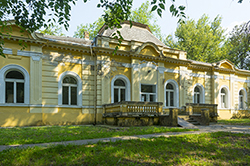 Photo: |
||
| A Maldeghem grófok rezidenciáját 1910-ben építettek a historizmus jegyében. Később a kastély Tallián Emil tulajdonába került és itt kapott helyet a vadászatain összegyűjtött trófea- és néprajzi gyűjteménye. A Maldeghem kastélyban az idők folyamán a rendőrség, a bank, majd pedig a könyvtár kapott helyet. Artúr Maldegem gróf kastélya 2001-ben került végül állami védelem alá a Szerb Köztársaság Kormányának határozatával. | ||
|
Schulpe-kastély |
||
 |
||
| Szervieczky Márkó Törökkanizsa ura építtette a kastélyt 1793-1804 között klasszicizáló stílusban. A kastély később házasság révén Schulpe család tulajdonába került. Schulpe György nagy műveltségű, humanista beállítottságú ember volt is, aki élete során egy igazságosabb, humánusabb és szociálisan rendezettebb társadalomért harcolt. Eszméit elismerték Európa- szerte, az Osztrák – Magyar Monarchiában a szociálpolitika nagy úttörőjének tartották. A kastély napjainkban szerb törvényszéki épület. | ||
|
Spitzer-kastély |
||
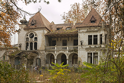 Photo: Donatello |
||
| This mansion was constructed between 1892. and 1898. by the influential Spitzer family, who were the owners of Beočin cement factory. Its architectural style features early Secession, but it also freely borrows from many other styles like Romanesque, Gothic and Baroque, making it very unique. Although it is proclaimed as a protected monument of special significance by the state, the castle is abandoned and suffers heavy deterioration and decay due to neglect. Today winds howl and weep through broken windows and empty halls, frost chips away ornaments from the walls, colours fade and slowly turn to sand. (nfilipovic.com) | ||
| A kastély a Vajdaság egyik legkiválóbb épülete, amely 1890-1892 között épült. Spitzer Ede cementgyár tulajdonos Steindl Imrét kérte fel a kastély megtervezésére. Eklektikus stílus jellemzi, hiszen több irányzat jegyei is ötvöződnek, mint a gótika, reneszánsz és a barokk elemek. Ennek ellenére mégis a szecesszió keretében említhetjük. Az úri lak belső és külső részei teljes mértékben egyediek, melyekhez tökéletesen illeszkedhettek a bútorok. A belső díszítésben előtérbe kerültek a magyar virágmotívumok. Az épületben a rózsaszín és a kék színek a leghangsúlyosabbak. A kandalló – ami sajnos mára megrongálódott – a felületét különleges rajzok és Zsolnay kerámia lapok ékesítik. A falakat gipsz és fa elemek díszítik. Az ablakok üvegeit is színes virágmotívumok díszítik. A hatalmas fából készült bejárati ajtón kovácsoltvas „S” betű kapott helyet, mely a Spitzer család kezdőbetűjét jelöli. A főbejáratot elhagyva félköríves lépcsőn keresztül jutunk le. Reneszánsz stílusú boltívek tárulnak a szemünk elé. Az oldalsó homlokzaton egy széttárt szárnyú turulmadár őrzi a kastélyt. A zöld ligetben egy kis kápolna maradványa is meglelhető, amit az évek során a vad növényzet szinte teljesen eltakart. A kastély tökéletesen ábrázolja az adott kor ízlés- és társadalmi világát. 1997-ben állami védelem alá helyezték, de állapota folyamatosan romlik. Ezt megelőzően könyvtárként és vendéglőként is használták. Az itt élő lakosság összefogásával 2004-ben felújították a mennyezetet, a cserepek átrendezése is megtörtént. A belcsényi Spitzer kastély mellett mintegy 80 uradalmi kastély és kúria áll a Délvidéken, sajnos a többségük méltatlan állapotban, magára hagyatva. Talán még reménykedhetünk, hogy ezek a csodálatos épületek valamilyen módon megmenekülnek a pusztulástól és nem tűnnek el, mint a kor, melyről mesélnek. (delvidekiutazas.com) |
||
|
Tallián-kastély |
||
 |
|
|
| Báró Tallián Béla nevéhez fűződik törökkanizsai fásítási program. Máig is minden lakos szívén viseli a fák további sorsának alakulásást. Visszaemlékeznek, hogy a báró ötfajta hársfát telepített, melyek teljes három hónapon át virágoztak a méhészek legnagyobb örömére. Tallián Emil szenvedélyes vadászként bejárta Afrikát, Dél-Amerika Amazon-vidékét, Indiát, Ceilont és Tibetet, ahonnan nem csak vadásztrófeáit hanem egzotikus növényfajokat hozott magával és ültette el a törökkanizsai parkba. Tibeti útja során járt Kőrösi Csoma Sándor sírjánál Darjeelingben, ahonnan a Ginkó Bilóba (páfrányfenyő) facsemetéket hozta.13 Saját birtokán közel hetven hold mintagazdaságot létesített, amelyen dísz- és gyümölcsfákat nevelt. A mintagazdaságot magasan szakképzett tájépítészek, gyümölcsészek és kertész szakemberek vezették Nagy Mihály Antal és Nisz Péter személyében. A környéken egyedüli üvegháza volt öntözőrendszerrel. A kukorica és gyümölcsfák terén olyan minőségi termelés folyt, hogy az európai piacon is keresett volt. A kastélyokat a háború után katonai kórházakká,árvaházakká alakították át. Az épület ma magántuljadonban van. | ||
|
Törley-kastély |
||
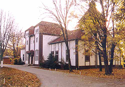 Photo: |
||
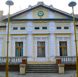
| Torley Gyula was built in 1882 in eclectic style. Gyula Torley in agriculture and horse breeding is directed at a high level on the estate. The cross-shaped building tower beautiful view of the surroundings. Today, the hotel and restaurant can be visited. Zobnatica (Serbian Cyrillic: Зобнатица, Hungarian: Andrásnépe) is a village in Serbia. It is situated in the Bačka Topola municipality, in the North Bačka District, Vojvodina province. The village has a Hungarian ethnic majority and its population numbering 309 people (2002 census). Zobnatica also is famose horse stable in Serbia. The tradition of horse breeding in this region lasted continuously for hundreds of years . As the ideal location for horse breeding Zobnatica is known almost 500 years . Horse farm Zobnatica was founded 1779.godine by Bela Vojnic. Zobnatica stable is the center of horse breeding and equestrian sports . It is famous for its horse farm with a tradition of education thoroughbred horses of over two hundred years . They offer tourist riding , riding school , horse-drawn carriage ride. With a horse farm is located and the Hippodrome with covered round pen . Guests can also visit the unique museum of horsemanship built in the shape of a horseshoe , a gallery of paintings and a former castle of the family terleeva which is now converted into a hotel. |
||
| Törley Gyula építtette 1882-ben eklektikus stílusban. Törley Gyula a mezőgazdaság mellett lótenyésztést is magas szinten irányította a birtokon. A kereszt alaprajzú épület tornyából szép kilátás nyílik a környékre. Ma szálloda és étterem, látogatható. A kastélyban a lovassportot, lótenyésztést bemutató Európában is egyedülálló patkóalakú tárlat is megtekinthető. A közelben található a Zobnatica-tó, lovaglásra, lovaskocsizásra is van lehetőség. | ||